
Langshan Mountain
2022-05-24
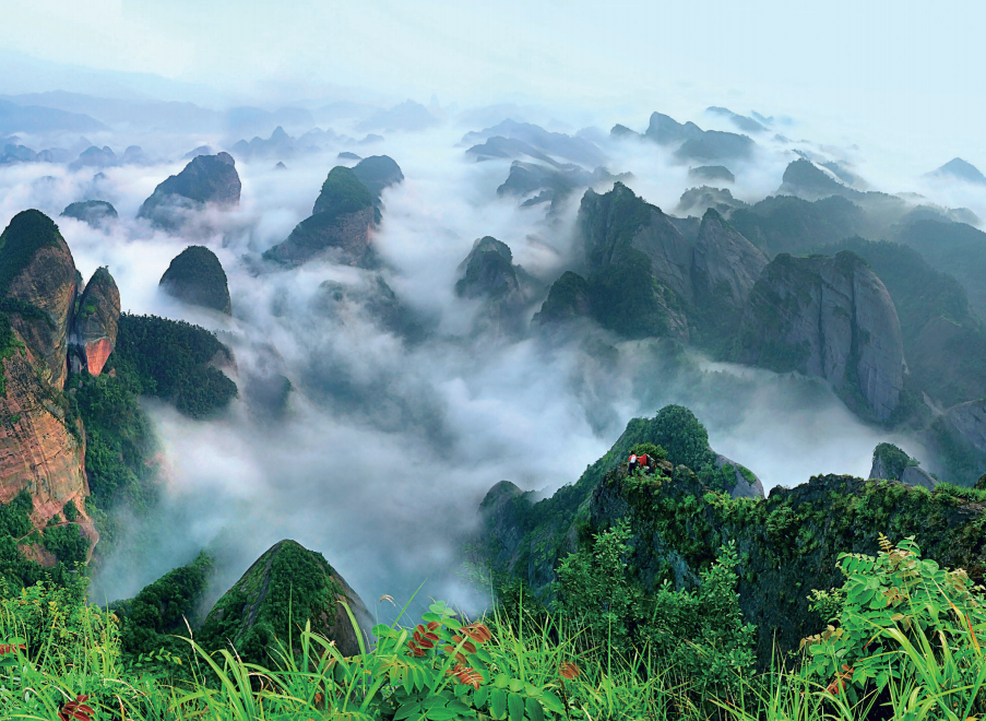
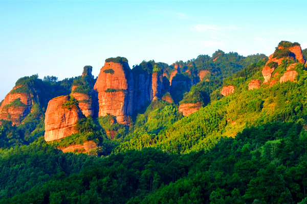
Langshan Mountain Scenic Area is world natural heritage as well as a national scenic area and a national geopark. It includes such six major scenic areas as Tianyi Lane, Chili Peak, Fuyi River, Bajiao Village, Zixia Cave and Tiansheng Bridge as well as 18 scenic areas with smaller size and more than 500 important scenic spots that have been found and named. It has three karst caves and one virgin forest, covering a total area of 108 square kilometers. As a typical Danxia landform, it is a rare environmental protection and natural scenic area.
Langshan Mountain is adjacent to Guilin in the South and Zhangjiajie in the North. It is the most typical Danxia landform in China with unique geological structure, which includes mountains, water, forests and caves.
Tianyi Lane
Langshan Mountain is adjacent to Guilin in the South and Zhangjiajie in the North. It is the most typical Danxia landform in China with unique geological structure, which includes mountains, water, forests and caves.
Tianyi Lane
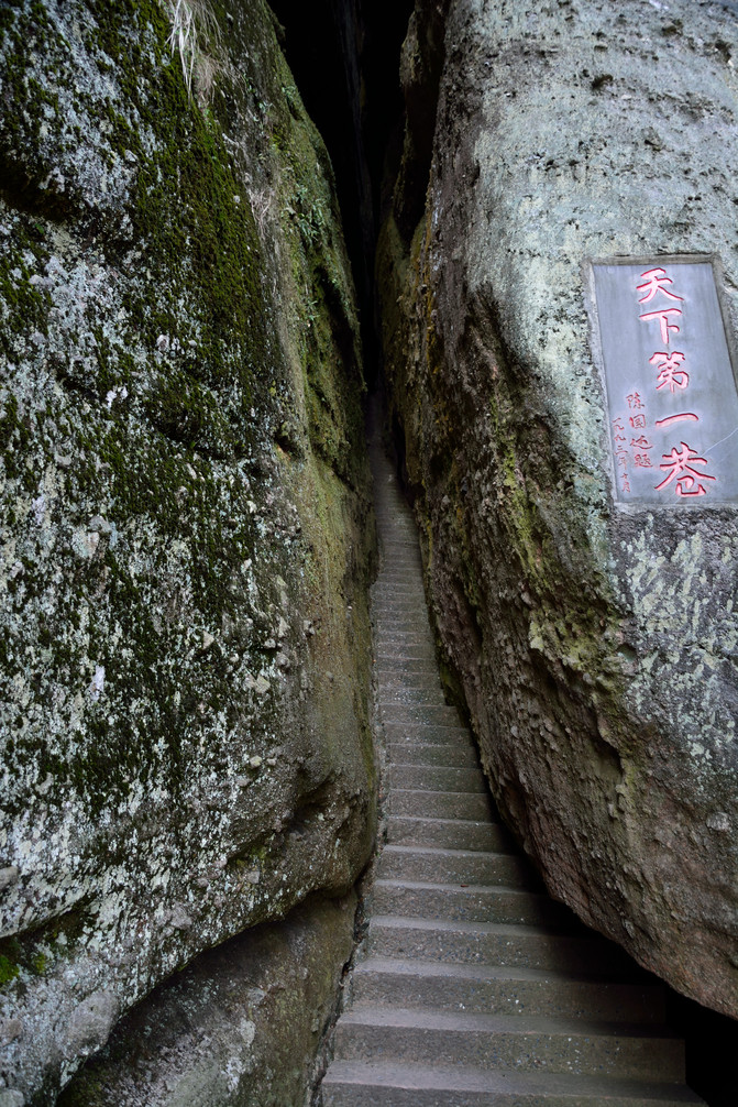
Tianyi Lane is one of the major scenic areas in Langshan Mountain. It was formerly known as cattle nose village because many pairs of stone holes in the East look like cattle’s noses. Renowned as the most unique lane in the world, it is 238.8 meters long, with stone walls on both sides of 80 to over 120 meters high. It can be described as one of the most magnificent landscapes in the world.
Chili Peak
Chili Peak

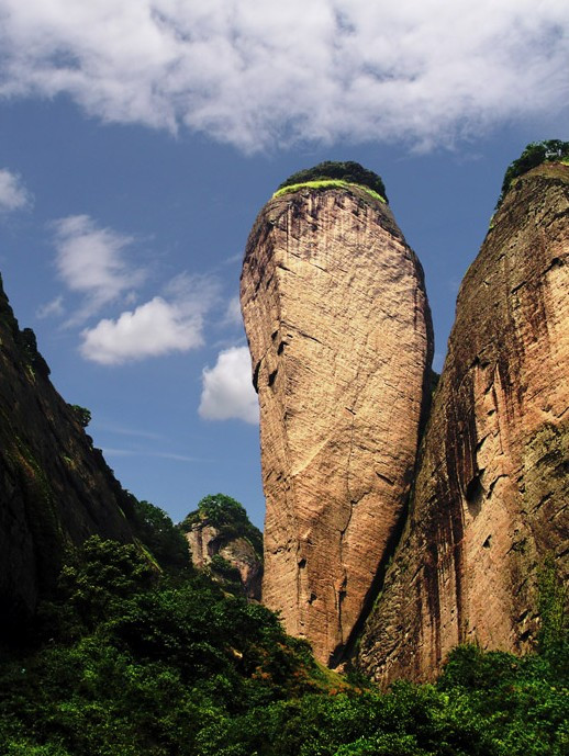
Chili Peak got its name because its mountain looks like an inverted chili. It is made up of a huge stone with 180 meters high. Large on the top and small on the bottom, its perimeter on the top of this stone is about 100 meters. It is red in color and multi-prism in shape. If you stand at the foot of the mountain and look up, you can see a huge stone with multi-prism shape towering into the clouds.
Fuyi River
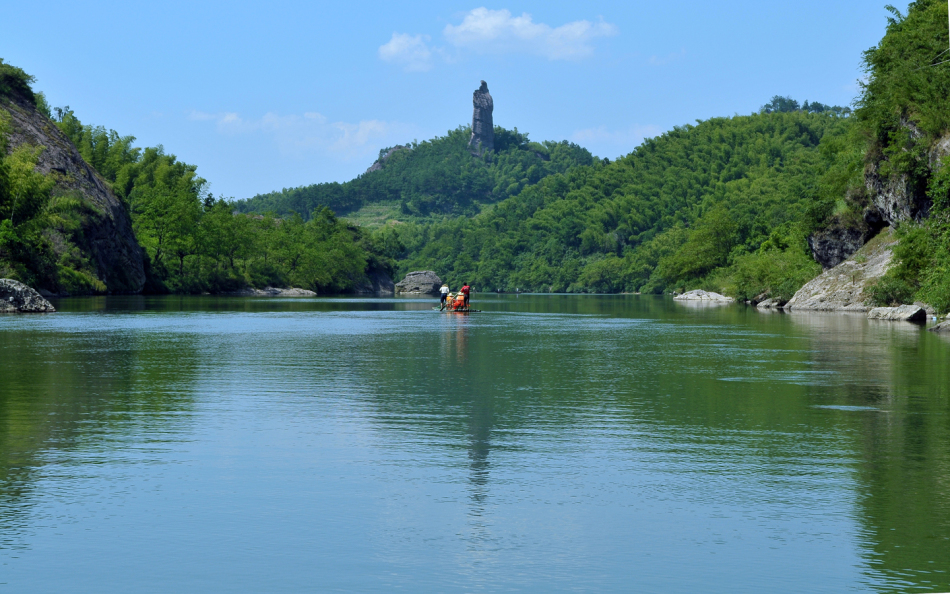
Fuyi River, originating from Maoer Mountain in Guangxi Province, is the mother river of Langshan Mountain. It has clear and placid water with water surface of around 100 meters wide. You can see peculiar rocks on both sides, willows on the bank and beautiful grass here, covering an area of 24.93 square kilometers.
Bajiaozhai
Bajiaozhai

Bajiaozhai, also known as Yuntai Mountain, is located at the junction of Datuo Village, Meixi Town, Ziyuan County, Guangxi Province and Langshan Town, Xinning County, Hunan Province. It belongs to Ziyuan County on one side and Xinning County on the other, so it has two names of Xinning Bajiaozhai and Ziyuan Bajiaozhai. “Ziyuan Bajiaozhai-Xinning Langshan Mountain” has formed a comprehensive scenic area with complementary advantages. The main peak, with a height of 818 meters above sea level. This scenic area enjoys its name for the eight protruding parts on the main peak.
Zixia Cave
Zixia Cave
Zixia Cave is a winding canyon with reddish-brown cliffs around it. Every time the sun sets, the Zixia Cave reflects thousands of rays. That’s why it got the name. It includes more than 20 scenic spots, including Zixia Palace, Wanjing Valley, Ziwei Peak, Honghua Red Cliff, Wuyun Village, Liu Guangcai’s Tomb, Zixia Pavilion, Elephant Trunk Stone and Red Tile Mountain.
Tiansheng Bridge
Tiansheng Bridge
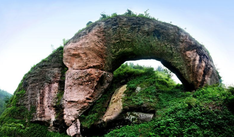
Tiansheng Bridge, the fifth wonder of Langshan Mountain, is 64 meters long, 14 meters wide, 20 meters high and five meters thick on the bridge. The whole bridge is in a circular arch shape. It is known as “the greatest bridge in Asia". Surrounded by mountains, Tiansheng Bridge is a semi-open scenic area. The inconvenient transportation makes it difficult for tourists to find the spot.
